Kefalonia, Greece
- Julie-Anne Justus
- Apr 27
- 5 min read
Updated: Apr 30
After our grey day in Valletta, our day in Kefalonia has been bright blue! Yamas!

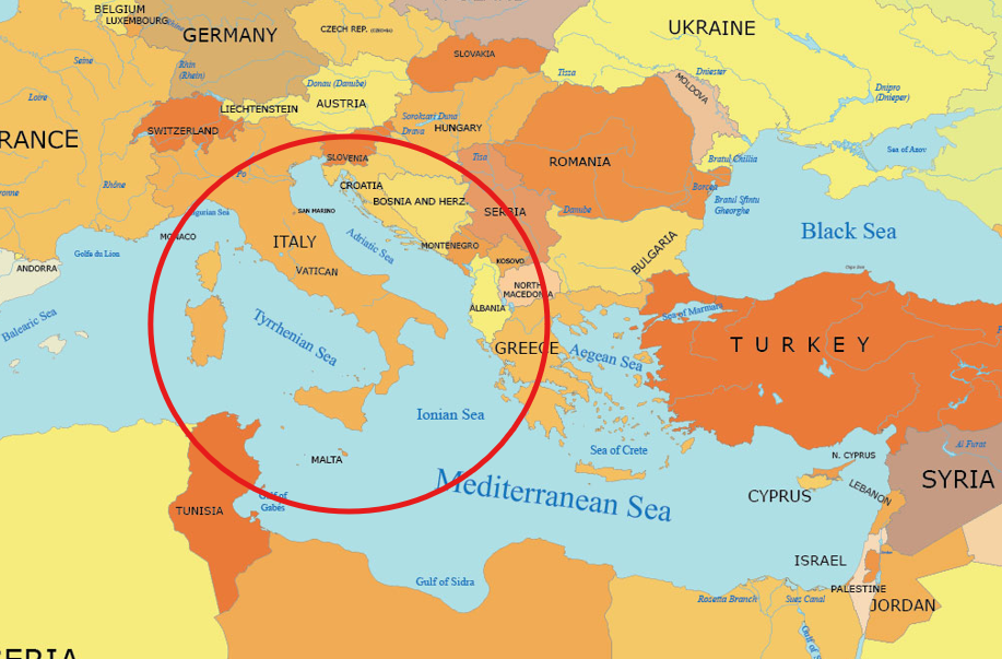
We are so excited to be back on a Greek island, and a new one (to us) at that. When we visited the Greek islands in September 2023, we were in the Aegean Sea east of the Greek mainland. Now we are in the Ionian Sea, on the west coast of Greece, closer to Italy than Turkiye.
Kefalonia is one of the seven (or nine, no one seems sure) Ionian islands. Corfu is one of them. Gerald Durrell's books about his childhood in Corfu — My Family and Other Animals; Birds, Beasts and Relatives — are unforgettable. If you haven't read them, do.


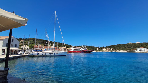
Argostoli, on the island of Kefalonia, is one of the busiest ports in Greece.

Our tour blurb encouraged us to 'discover charming Argostoli, flowing up from the turquoise bay along the sides of white limestone hills with its colorful fishing boats, vibrant markets and relaxing atmosphere', and I think that it's spot on.
Kefalonia is very green compared to some of the Greek islands we've visited. There is water, particularly underground water, across the island, but the soil is very poor and the only plant crop that grows commercially is olives. Olive oil was used to trade for food in the past. We also noticed a lot of bee hives across the island. Cultivated honey, with bright little boxes used by farmers. I tried to get some photos but no luck.


We set off by coach, up into the hills, along winding roads. We're crossing the island to Sami village on the east coast of the island. The island of Ithaca lies alongside Kefalonia and it's visible as we approach the coast. Ithaca, you'll remember, is the home of Odysseus, the hero of Homer's Odyssey. Much of the Odyssey is about Odysseus's struggle to return home, constantly thwarted by the meddling gods. I actually thought Ithaca was an imaginary, symbolic place (silly me), so I am delighted to discover that it's a real island. We'll visit it next time!
Kefalonia is very 'diversified', according to our guide Martin. It has mountains, lakes and rivers. The tallest mountain is more than 1500 m, and we certainly are climbing quite swiftly. The black firs, also called dark firs, are endemic to the island. I don't have great photos of these trees but you can spot the dark blobs on the mountainsides that are clearly not cypress. Oh, and the local grape is called Robola. Our guides always tell us about the local grapes.


Kefalonia, and the other islands on this side of Greece, was ruled by the Byzantine Empire and then the Venetian Republic for hundreds of years. Traces of Venetian times and Venetian language are still evident in the local dialect. And then it was ruled by France, and then by Britain, before becoming part of Greece. But where are the old ancient buildings? Kefalonia suffered two disasters: (1) occupation by the Axis forces during WW2 (I'll come back to this) and (2) a massive earthquake in 1953. Buildings that weren't shattered by German bombing in 1943 were destroyed by the earthquake a decade later. Consequently, almost all the houses look very modern and less than one hundred years old.
Some of the ruined villages are still visible on the hills, but they're high up and difficult to see through the bush. If you look carefully in the photo below, you can just make out a line of ruined buildings high above the new structures. When villagers rebuilt after the earthquake, they built their houses closer to the road.

Near Sami we stop at the famous Melissani Lake (or Melissani Cave). The cave is named after the mythological Melissani, a nymph who committed suicide because the god Pan spurned her. Archaeologists have discovered ancient artefacts from around 300 BC, suggesting that people saw this as a site sacred to Pan. One of the partying gods!
Melissani Lake is a cenote, the only one in Greece — actually, the only one in Europe. Most of them are in Mexico, but there's another in Thailand and we do have a few in Australia. Anyway. It's an underground lake formed in limestone with crystal-clear turquoise waters and a collapsed roof that lets in sunlight. Sea water flows in one side of the island, near Argostoli, and flows out 14 days later on the other side of the island, having flowed through this limestone chamber. In the 1800s the flow of this water was used to power a mill, where flour was produced.
We stand in a long queue. A very long queue. The process is a bit production-line-ish, but I don't begrudge that. Locals have to take advantage of whatever attractions they have. Finally we walk downwards through a tunnel in the limestone ...


... and emerge into this spectacular hole in the earth filled with bright blue water. Well, the part that's in the sunlight is bright blue.


The cenote is really stunning. We're here at about 10.30 am, and the sun is not directly overhead so the full blue colour is only on one side of the lake, but what is illuminated now is glorious. Our oarsman is wearing a natty orange jacket and is very skilled at manoeuvering both elderly tourists and the boat around the lake, into and out of the cave with its stalactites, pigeons and bats.


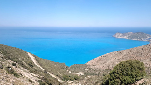
The road from Sami north to the top of the island has a breathtaking view of the turquoise bays and white limestone cliffs. It was in this part of the island that the movie Captain Corelli's Island was filmed, around 2000. (I loved the original book by Louis de Bernières.)


If you've read (or seen) Captain Corelli's Mandolin, you'll know that it's set in WW2 when most of the occupying forces in Kefalonia were Italian, with a smaller force of Germans. Italy signed an armistice with the Allies in 1943, but the Germans were a bit unhappy about this and to cut a long story short, there came a time when the Germans fought against the Italians. Many Italians fought as partisans against the Germans. The Italians eventually surrendered and the Germans executed thousands of the suviving soldiers.
When WW2 ended, Greece descended into civil war. It was only around 1949 that peace returned to this area.
We arrived in the village of Fiskardo in the north of the island, the only village to escape unscathed from the earthquake.


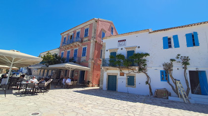


We wandered along the harbour. Happy days.


Ken decided it was time for a Greek beer. I decided it was time for a coffee and baklava. We were both contented.


But wait, there's more stunning blue beauty! Myrtos Beach is one of Greece’s top ten beaches. We could only admire it from the clifftop. (We think that one reason it's so highly rated is that it's extremely difficult to reach! It's very unlikely to be overcrowded.) Apparently the colour of the Bay of Myrtos changes with the time of day. We were obviously there at turquoise o'clock.


Kefalonia (and for all I know, Greece) is focusing considerably on renewable energy. With 220 sunny days a year, Kefalonia is pushing the uptake of solar power.
Many people continue the traditional practice of fishing in boats, but the largest industry in Kefalonia is fish farming. These photos are all in different parts of the coastline. Prawns are one of the biggest crop (is that the right word?) and most are exported to Italy.


Kefalonia is the sixth biggest island in Greece, but it's very sparsely populated. Many people left the island after the earthquake. Our guide noted that pre-earthquake the population was 85,000 people; it's now 35,000. The island has 365 villages — during winter, some are completely deserted. Even in summer, some villages have fewer than 50 people. Most people live in the south.
It's a great place to visit.
Time to end our glorious blue day. I hope that Brindisi tomorrow is just as blue!


Next stop: Brindisi, Italy
This really looks better on a bigger screen. www.julie-anne.online


Comments